
Maps For Kids is here!
Three new wall maps for curious kids (and kids at heart).
Welcome to Chartography.net — insights and delights from the world of data storytelling.
MAPS FOR KIDS is here.
Over the past year you’ve watched this project take shape: early topic lists, logo sketches, research trips, Ben-Day experiments, naked diagrams waiting for labels. Today the first three finished wall maps are real objects in the world—ink on thick Japanese matte paper—and you can finally order them from Visionary Press.

Maps for Kids starts from a simple idea: almost anything can be treated as a map. Geographic projections, statistical charts, and pictorial diagrams are all ways of flattening the world so we can see and understand better.
But the real magic happens when we enjoy those maps together. Each design is meant to be enjoyed side by side—loaded with kid-sized points of engagement and quiet cues for parents, big siblings, and teachers to help narrate what’s going on.
Let’s meet our three maps.
1. Food Energy
A chart about how everyday foods power our bodies.
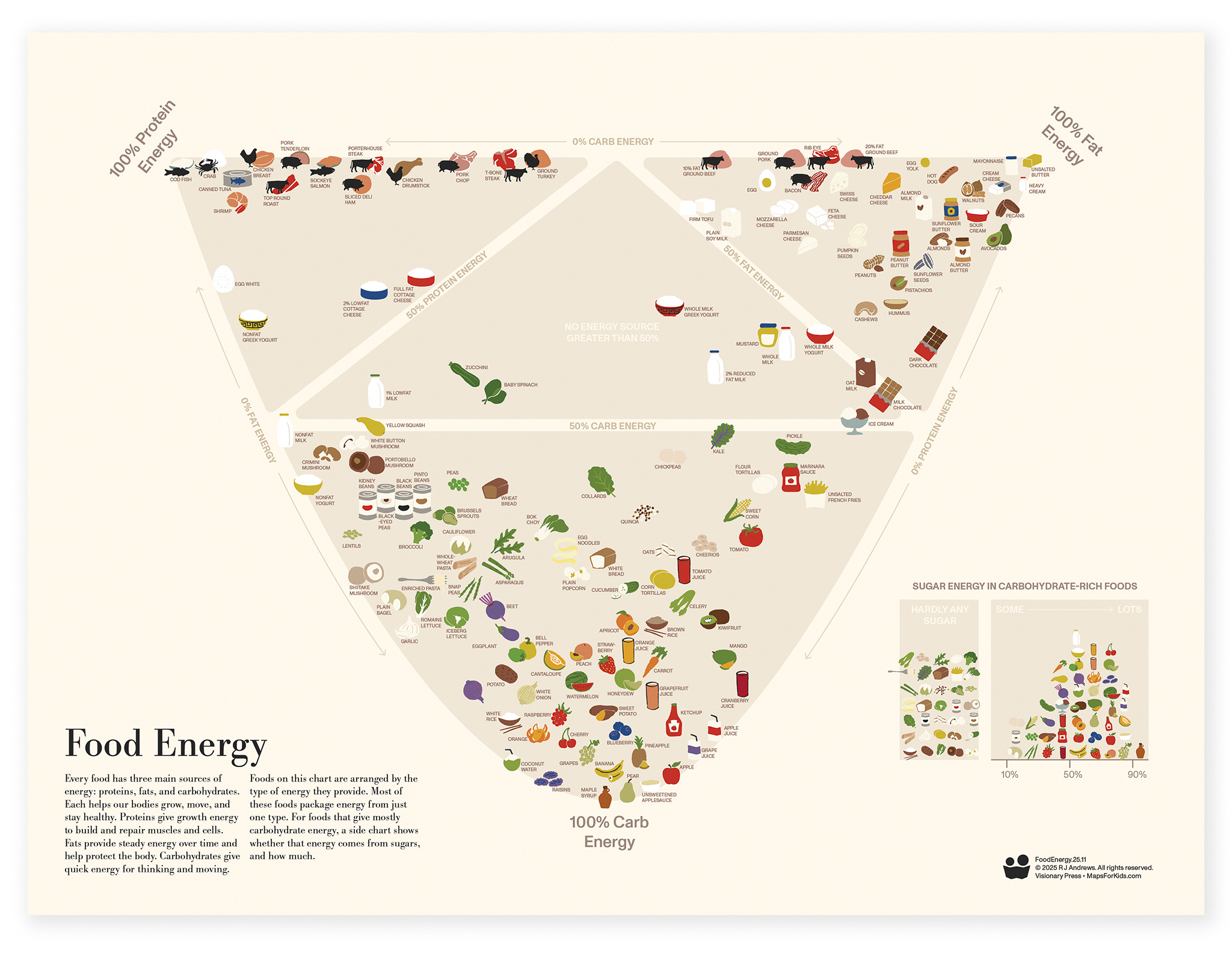
Food Energy arranges familiar snacks and ingredients into a colorful wall chart. 146 foundation foods are placed by how much of their energy comes from fats, proteins, or carbohydrates, so kids can literally see the difference between an avocado, a yogurt, and a bowl of rice.
Learn what each macronutrient does — quick energy, steady energy, growth energy. A small inset focuses on carbohydrate-rich foods and shows which ones get most of their energy from sugars. The result is a poster that works as both a kitchen conversation starter and a gentle statistics lesson. Kids compare what they love (and don’t love) to eat while grownups finally have a map to all the foods they’ve eaten their whole life.
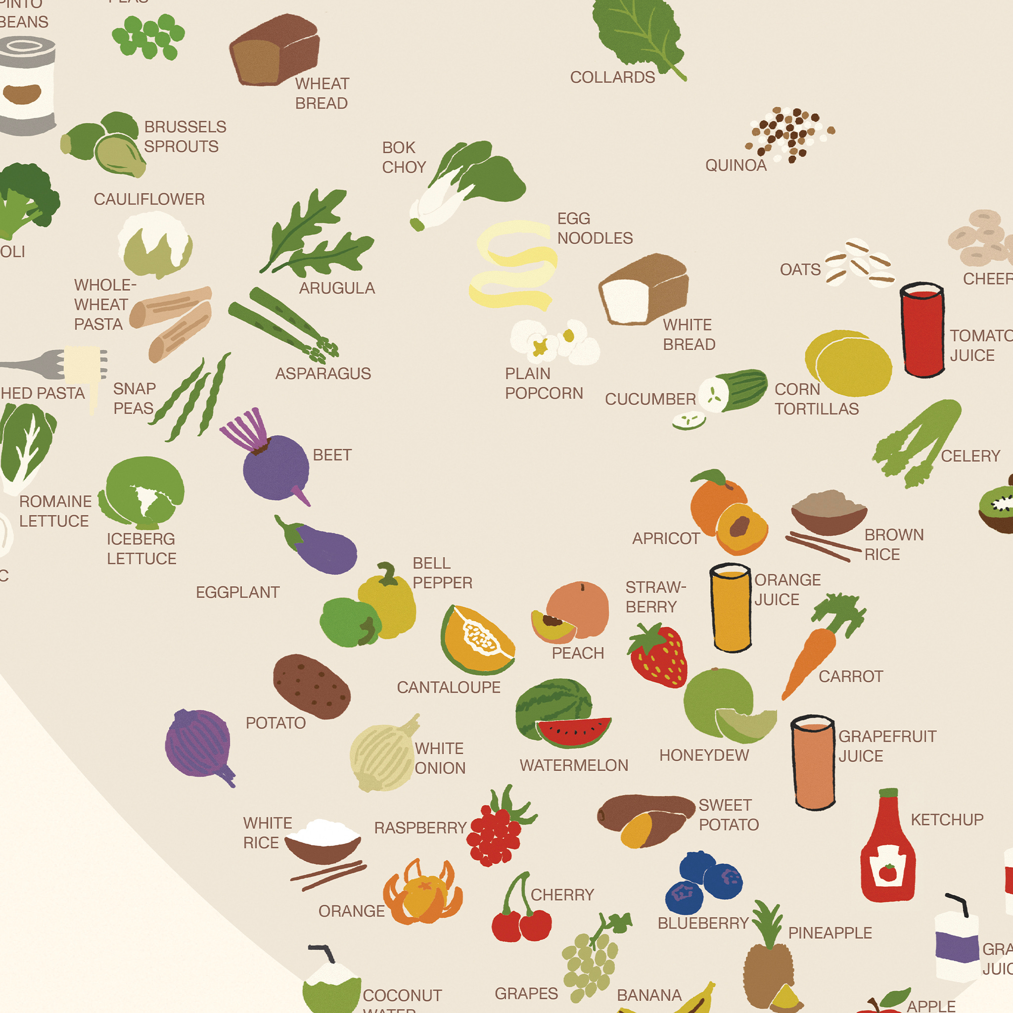
Hang it on the fridge, in a classroom, or anywhere people enjoy food.
2. Earth Biomes
A portrait of the living planet at arm’s length.

“Earth Biomes” is an illustrated wall map built from three globes. They line up so continents continue across them, with the bottom globe flipped to reveal the South Pole. Color washes across the land to mark major biomes—rainforests, deserts, tundras, and more—while ocean blues darken to show where the water runs deep.
This design is a collaboration with Robert Simmon, earth-visualizer extraordinaire.
A legend of plant silhouettes and tiny “recipes” of thermometers and raindrops shows how temperature and rainfall combine to shape each landscape. As kids explore, patterns snap into place: green belts hugging the equator, deserts hiding in mountain rain shadows, icy crowns at the poles. It’s an invitation to see Earth not just as “land and water,” but as a set of living systems.
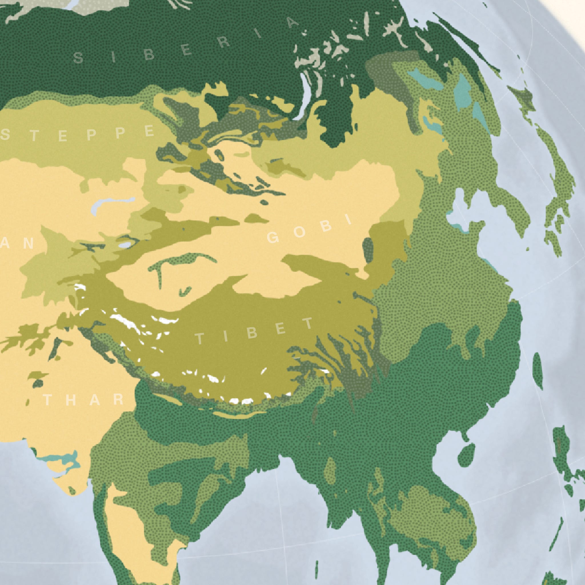
I’ve shown its test prints to many people and each one had the same reaction: That’s beautiful!
3. Steam Locomotive
A diagram that shows how heat turns into motion.
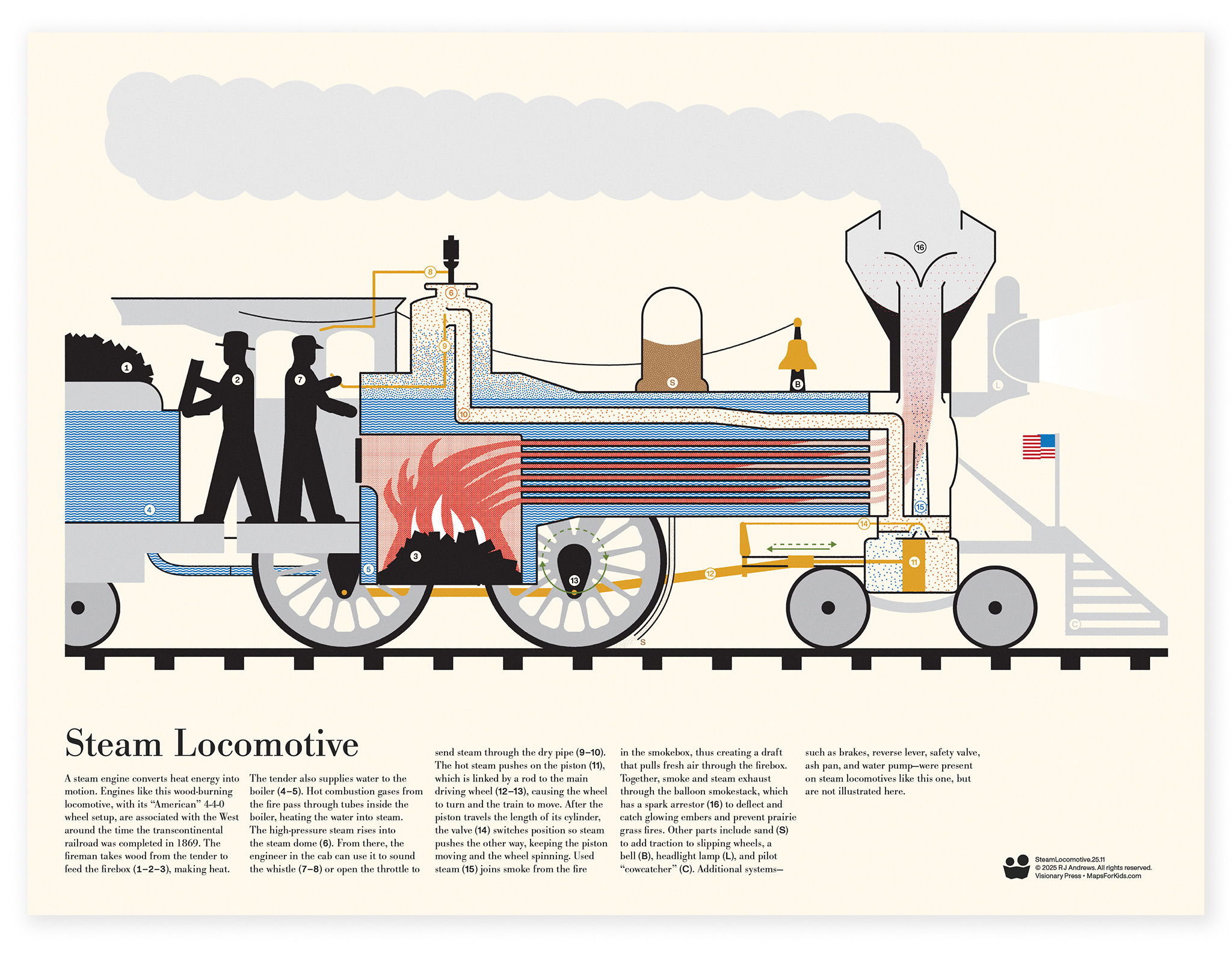
“Steam Locomotive” tells the story of a classic wood-burning 4-4-0 engine—the kind that helped stitch the United States together in the 19th century. The engine stretches across the page like a mechanical animal, every major system illustrated and explained.
A short guiding narrative walks you from the tender full of wood and water, into the firebox and boiler, up to the steam dome, and finally down to the piston and driving wheels that pull the train forward. Around that journey spot extra details: the whistle that sings with steam, sand that helps slipping wheels grip the rails, and a tall smokestack that catches sparks before they set the prairie on fire.
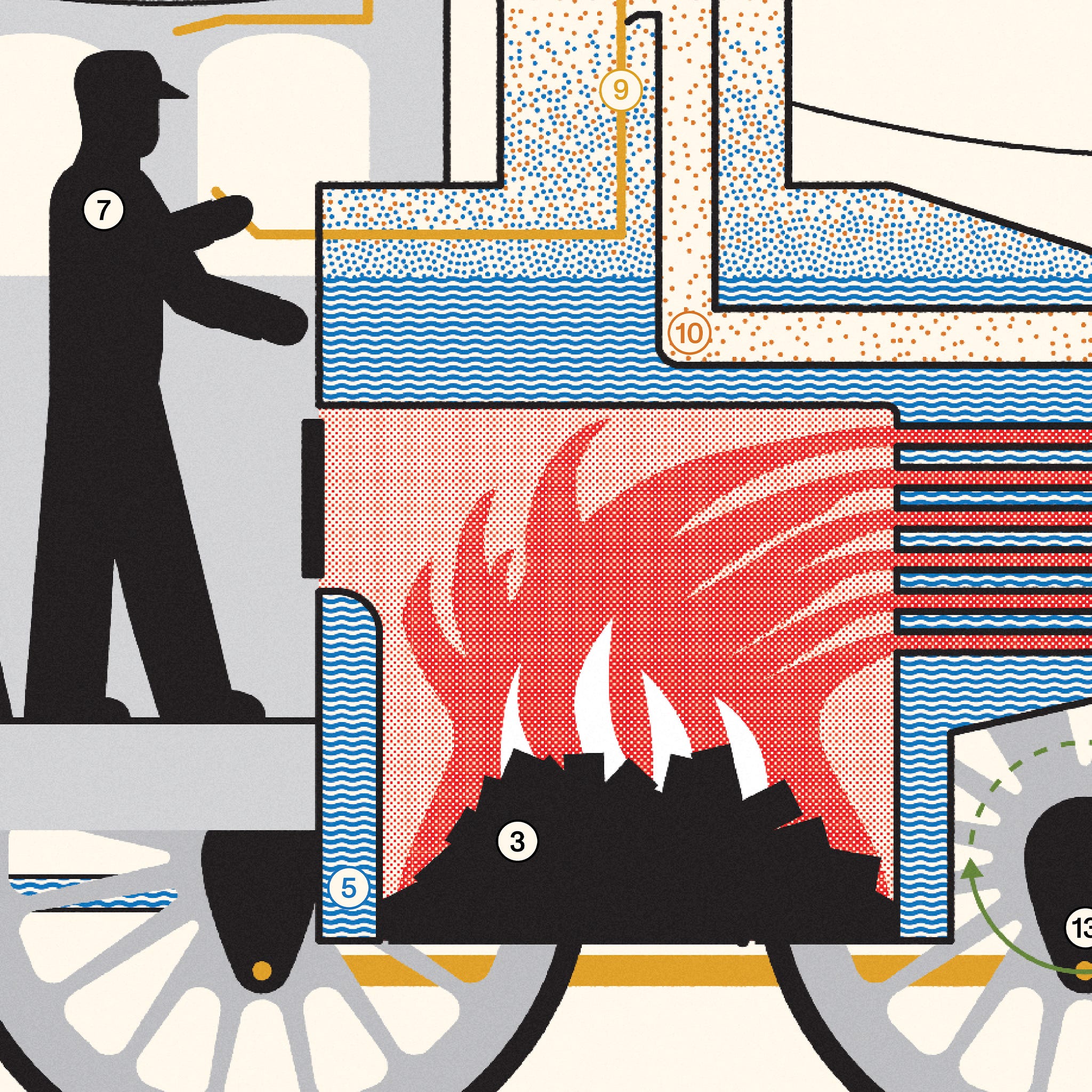
After using it to explain how a train works to my 3-year-old, I was startled to find him soon drawing cutaway diagrams of steamies, revealing their firebox and boiler tubes inside.
How to get them
Buy a single poster for $45
Or get all three for $99
The three-poster package is a balanced introduction to information graphics: one diagram, one chart, one map. Steam, snacks, and the whole planet—a tiny gallery of how we can map different kinds of knowledge.
What they’re printed on
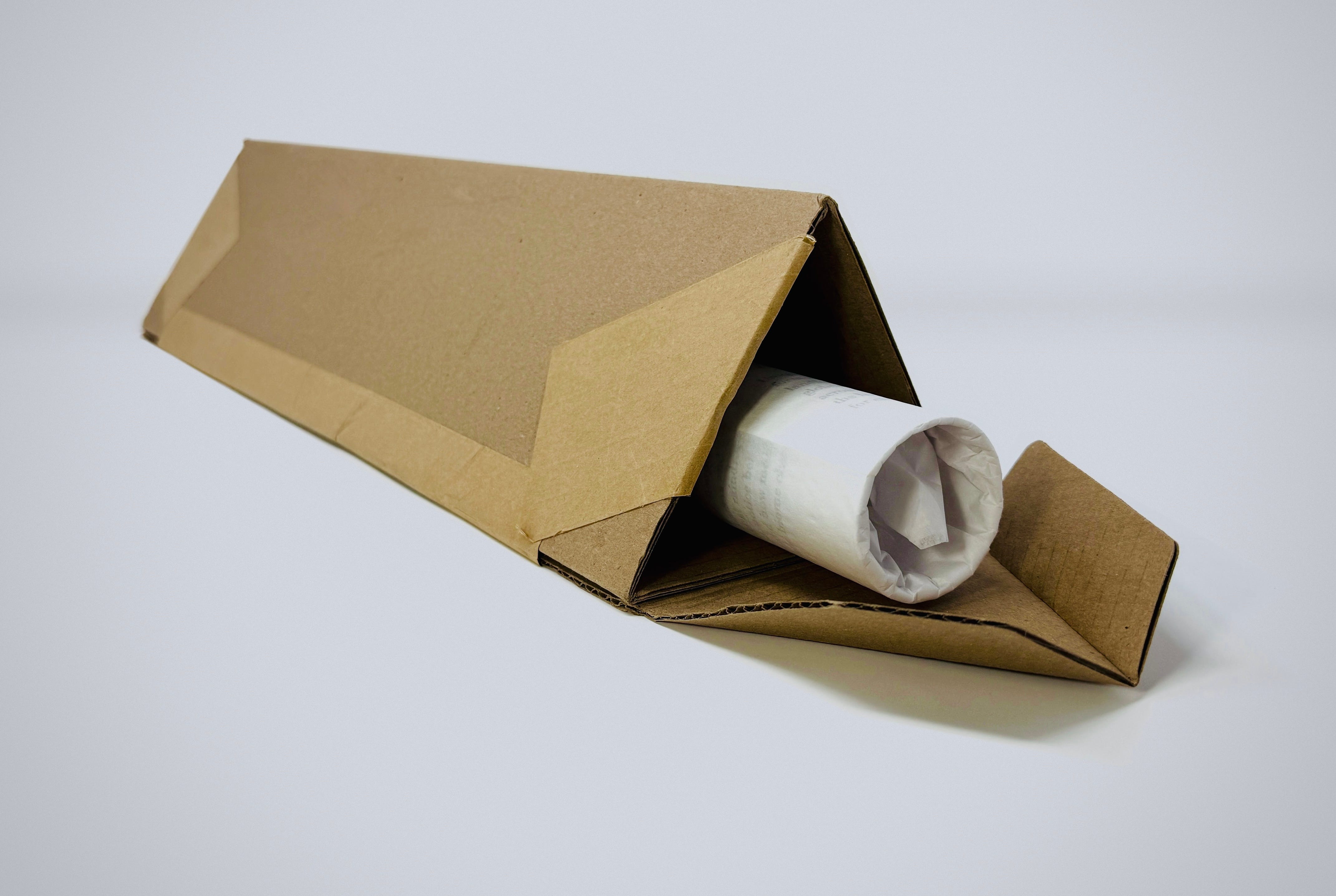
These are not flimsy handouts.
Each poster is printed on thick, Japanese-made matte art paper—the kind that feels substantial in your hands and doesn’t glare under bright lights. Colors are crisp, so fine labels and little details pop.
Posters are rolled in protective tissue and shipped in a triangular carton, which means they arrive ready to gift: no creases and no tube wrestling
Behind the scenes, an international network of printers produces the posters close to where you live. That reduces shipping distance and customs friction, so your order tends to arrive faster (and cheaper) than if everything had to travel from California.
For everyone in the United States, Visionary Press is offering free domestic shipping for Black Friday and Cyber Monday.

Who these are for
Kids who ask “How does that work?” and “What’s that called?”
Grown-up enthusiasts for inspiring design
Folks like teachers, librarians, and pediatricians looking for visual explanations that respect kids’ intelligence
Everyone hunting for a holiday gift that isn’t another plastic thing with batteries
I appreciate you following my year-long series chronicling this passion project. Thank you for cheering Maps For Kids along while it was still wobbly. This is the moment when the sketches and stories turn into artifacts you can actually unroll, hang, and enjoy.

I’m excited to finally send these maps out into the world—and onto the walls of the kids (and kids at heart) in your life.
Onward!—RJ
About
Chartography is by RJ Andrews and the newsletter of Visionary Press and Info We Trust.
RJ Andrews is obsessed with data graphics. He helps organizations solve high-stakes problems by using visual metaphors and information graphics: charts, diagrams, and maps. His passion is studying the history of information graphics to discover design insights. See more at infoWeTrust.com.
RJ’s book, Info We Trust, is out now! He also published Information Graphic Visionaries, a book series celebrating three spectacular data visualization creators in 2022 with new writing, complete visual catalogs, and discoveries never seen by the public.
I LOVE your "Maps for kids" logo! I mean, I love the posters too, but that logo is an extra nice touch!!